Gallery


About
The Track
THE DRIVE
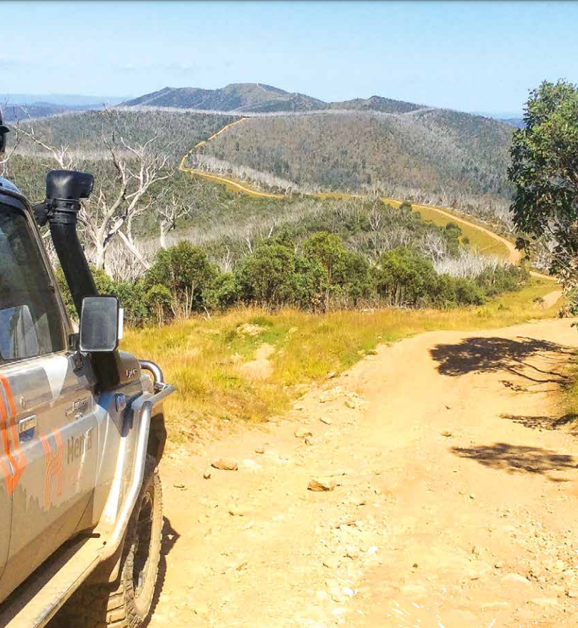
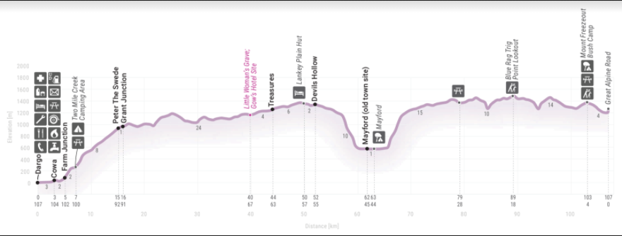
This spectacular track starts in Dargo as you head north up Dargo High Plains Rd passing Farm Junction and Grant Junction, the road turns to gravel 21km from Dargo as it passes through the Freda Treasure Tree Reserve. Nearly 26km from Dargo a track on the left leads 100m to Treasure’s - Mt Ewen Huts, which is in fact a collection of old huts in varying stages of disrepair. There are a couple of spots to bush camp around here, if not at the huts themselves.
The Gows Hotel site can be found just to the east of the road 43km north of Dargo. Just 200m south from here, opposite Ritchie Rd, there is a small grave to a pioneer woman who died here.
You’ll pass through an area of fenced high plains grazing land, and come to Lankey Plain where you turn east onto the King Spur Tk to Mayford.
Just off Dargo Rd a track on the left leads 300m to Lankey Plain Hut. Back on the King Spur Tk you pass through a gate and close to the junction of the Long Spur Tk – to the south there are some fabulous views and spectacular bush campsites overlooking Devils Hollow .
From here the track deteriorates and descends steeply into the Mayford Valley. Once at the bottom of the range, 11km from the Dargo Rd, you’ll enter a cleared area and pass some bush campsites and cross the upper reaches of the Dargo River. There are three more crossings of the stream in the next 3km before you reach the track’s end at the far side of the clearing that was once the old townsite of Mayford. Very little remains to be seen here, although an occasional pile of rocks is testimony to an old hut or building.
Back on the main Dargo Rd it is just 6km to the junction of Blue Rag Range Tk, just 59km direct from Dargo and 12km south of the Great Alpine Rd.
Turn onto the Blue Rag Range Tk, which immediately becomes steep. Just over 3km along you veer right, staying on the Blue Rag Range Tk with impressive views of the track in front of you. A roller-coaster ride of just 7km from the Dargo Rd, that’s rutted and eroded in places, brings you to the Blue Rag Trig Point, and the most impressive views in all of the High Country.
From here you’ll need to return to the Dargo Rd, as the Blue Rag Range Tk dead-ends at the Wongungarra River. Camping is possible at the end of the track, but there are no facilities and very little space. Once back at the Dargo High Plains Rd, turn north for an easy run of 12km to the Great Alpine Rd at Mt Saint Bernard, just 12km from the resort of Hotham Heights.
THINGS TO DO
While you’re in the area, you should seriously consider taking time out to hike the Razorback Walk. It is an amazing bushwalk from just north of Mt Saint Bernard to the summit of Mt Feathertop – the state’s second highest mountain. You can make the adventure a day-long outing or spend the night at Federation Hut. If you walk this trail in springtime or early summer, you’ll enjoy the High Country’s diverse array of alpine wildflowers. Hunting for deer is allowed in much of the area south of Hotham and across the Dargo High Plains. Fishing for trout and native species is reasonable in the headwaters of both the Wongungarra and Dargo rivers. The McMillan’s Walking Track crosses Dargo Rd near Lankey Plain. For experienced, well equipped walkers it can be followed south to Talbotville (50km, 3 days) or east to the Victoria River via Mayford (25km, 2 days).
4WD Adventures Top 100 - Track #3
GRADING:
4WD, Medium TIME One day.
DISTANCE
107km, Dargo to Mt St Bernard via Mayford and Blue Rag Trig Point.
LONGEST DISTANCE WITHOUT FUEL
158km, Dargo to Bright.
BEST TIME OF YEAR
Late spring to early autumn. Seasonal road closures apply during winter.