Shop

GRADING: 4WD, Medium.

TIME: Overnight.

DISTANCE: 190KM, Sawtell to Woolgoolga. 

LONGEST DISTANCE WITHOUT FUEL: 69KM, Nana Glen to Woolgoolga.

BEST TIME OF YEAR: All year round - although in Winter, temperatures can be bracing.

PERMITS AND FEES:   National park camping fees apply.

MAPS: Hema's 'New South Wales' State Map.

THE DRIVE:

The trip begins in Sawtell, which threatens to swallow your motivation before you even reach escape velocity. It’s low-key but far from ramshackle, and with an effortless coffee culture brewing along its main esplanade – it’s what Byron Bay was before capitalism took notice at the turn of the millennium.

To douse your inner hipster’s fire with a refreshing splash of the wild, head north out of town along Hogbin Dr then west along Stadium Dr towards Boambee State Forest. Englands Rd becomes unsealed as you begin to climb the hills around the North Boambee Valley before it turns into Gum Flat Rd and the track becomes more interesting — a change that’s in perfect timing with the increase in elevation. The lower sections at the edge of the forest are easily flooded, and when dry they can present some challenging ruts and wash-outs.

After exiting the forest, head west along the sealed arterial road taking in the quaint Upper Orara countryside before you plunge into the overgrown masterpiece of Bindarri National Park. Within the Park are easy gravel tracks, pockets of intense rainforest and Bangalore Falls – a short walk from the titular picnic area and a sight well worth the stroll. Continue through Bindarri, exiting to cross the Eastern Dorrigo Way before striking north along Moleton Rd to Cradle Creek and then Black Mountain Rd — all easy and scenic unsealed work to bring you to the doorstep of Nymboi- Binderay National Park.

Break off to The Junction Rd, which becomes a somewhat tough steep descent in anticipation of your campsite for the night: The Junction Camping Area. Sitting at the confluence of the mighty Nymboida and Little Nymboida rivers, The Junction is a simple campsite in an attractive location. The rivers’ clear, amber water can be heard rushing above the crackle of a night fire, and its constant pounding is a visceral reminder of the wilderness surrounding you on all sides.

After a morning dip in the Nymboida’s boulder-strewn flow, retrace your tread out of the Park until you deviate left onto Moleton Rd towards the sealed Coldwater Creek Rd and the tiny township of Nana Glen (home to the classic Idle In Cafe´). Breeze along the arterial roads (Grafton St and Bucca Rd) for 12km, before turning left onto Sherwood Rd.

Once inside Wedding Bells State Forest, take the Short Cut, Boyds Rd and then Marys Waterhole Rd through to Sherwood Rd. This section is scenic and not without potential 4WD challenges, and this motif continues as you wind your way into Sherwood Nature Reserve.

Bending east, Sherwood Creek Rd touches Conglomerate State Forest as you head to Upper Corindi and the end of the unsealed part of the drive. As with the other state forests and reserves in the Coffs Harbour hinterland, Conglomerate SF is a maze of tracks that offers the chance for some hair-raising four-wheel driving. If you have time and fancy your skills, a deeper dive into these lesser-maintained tracks is a must.

At the end of Sherwood Creek Rd, take Eggins Dr south past Arrawarra and into Woolgoolga — another seaside town on the Mid North Coast currently mixing a sweet draught of culture and coastline. Drive until you hit the car park at the headland, then wander out to gaze at the ocean with sea spray in the air and rainforest remnants still clinging to your tyres.


FERN GULLY

This journey traverses traditional lands of local Aboriginal tribes such as the Gumbaynggirr people, who first recognised the inherent beauty around

Bindarri and Nymboi-Binderay national parks. The Gumbaynggirr word ‘Bindarray’ means ‘many creeks’, ‘Binderay’ means ‘river’, while ‘Nymboi’ is the river’s name, bestowed upon it by its people.

Rainforest accounts for less than a third of a per cent of Australia’s landmass, but within that tiny space, about half of all Australian plant families and a third of its mammal and bird species reside. Its rarity and complexity is an alchemical soup that yields much and hides more within its limited confines. The rainforest is, scenically and statistically, perhaps the most significant land-based environment on Earth. And so, to find such dense and consistent stands of it as far south as Coffs Harbour’s hinterland (and further even) is almost as unexpected as it is rewarding.

Particularly majestic examples of rainforest pop up in the valleys of Bindarri National Park, Boambee State Forest and even around the Moleton area, as well as other spots outside of any park or reserve between Sawtell and Woolgoolga.

4WD Difficult

4WD ADVENTURES TOP 100 - TRACK #2 - MADIGAN LINE

GRADING: 4WD, Difficult.

TIME: Ten days.

DISTANCE: 722km, Mount Dare to Birdsville.

LONGEST DISTANCE WITHOUT FUEL: 722km, Mount Dare to Birdsville.

BEST TIME OF YEAR: April to October.

PERMITS AND FEES: A permit is required from the Central Land Council.

MAPS: Hema’s Great Desrt Tracks Simpson Desert Map.


THE DRIVE

From Mount Dare head north towards Old Andado, crossing the Finke River along the way. After Old Andado the track heads north then east through Mac Clark (Acacia Peuce) Conservation Reserve. 

The first of Madigan’s camps is on private land so Camp 1a was created on the main track. As you head across the desert you’ll be looking for small plaques on star pickets that were placed to show the locations of Madigan’s camps by Owen Correa Outback Expeditions in 1994. Camps 2, 3 and 4 are no longer accessible to the public, so the route bypasses these and heads directly to Camp 5, near the intersection with the Colson Track.

East of Camp 7 is where the dunes become trickier, and it’s a good idea to deflate the vehicle’s tyres even further at this point. As you head east across the northern Simpson Desert there is little to interrupt your views of the red sands. While this trek was once a purely

cross-country route between the noted GPS positions for Madigan’s camps, the track has become more defined over recent years. However, in places, particularly between camps 7 and 13, it is still often not clearly visible, especially early in the season.

The track becomes more defined as you hit the eastern end, particularly where it joins the Hay River Track (see Track 71). At Camp 15 the Hay River Track heads north to Batton Camp and Jervois Station on the Plenty Highway, and south to Camp 16. At Madigan’s Blaze Tree turn east becoming as the track becomes less well-used crossing the NT/QLD border, heading across Munga-Thirri National Park.

As the track passes Camp 19 and leaves the Park, track conditions become easier for the run southeast towards Birdsville. On the way south it passes Camp 20, Camp 21 and the ruins of Annandale Station before reaching Camp 22 – the last one that is accessible to the public.

From this point, it’s a run down Eyre Creek to the QAA Line (see Track 70) for a visit to Big Red on the way into Birdsville.


MADIGAN’S ROUTE

Dr Cecil Thomas Madigan led a scientific expedition across the Simpson Desert in 1939. His party of nine men and 19 camels left the remote homestead of Old Andado on June 4 and, after considerable hardship, arrived safely in Birdsville on July 6. He named the desert after Allen Simpson, who was then president of the South Australia branch of the Royal Geographical Society of Australasia. Madigan’s book, Crossing the Dead Heart, is interesting reading that can add a lot to your experience. 

In 1975, Denis Bartell began a series of more than 40 adventures that included the first vehicular crossing of the Madigan Line. Bartell was the one responsible for giving Nappanerica Dune the nickname ‘Big Red’.


4WD Extreme

4WD ADVENTURES TOP 100 - TRACK # 29 - CREB Track

GRADING: 4WD, Extreme.

TIME: Day trip or overnight.

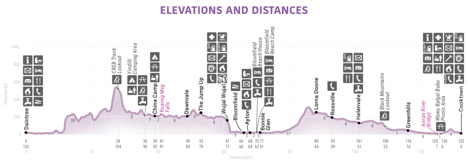
DISTANCE: 132km, Cooktown to Daintree.

LONGEST DISTANCE WITHOUT FUEL: 82km, Wujal Wujal to Wonga Beach (towards Mossman).

BEST TIME OF YEAR Dry season: May to October. Don’t try it after any rain and always check with locals for the latest information before attempting.

WARNINGS: Even light rain can make some of the descents extremely dangerous – don’t drive on the track when it has been closed by the Council. The top of Roaring Meg Falls is a recognised women’s site for the Buru people, so signage asks men to not visit

the site. No alcohol is permitted in the Roaring Meg Falls area. Camping is only permitted in the designated zone; do not camp at the swimming area (beach) or beside the river’s edge. Alcohol restrictions also apply in Wujal Wujal.

PERMITS AND FEES: Visitors are asked to contact a representative of the Burungu Aboriginal Corporation (traditional owners) prior to accessing Roaring Meg Falls. Fees apply for camping.

MAPS: Hema’s Cape York.


THE DRIVE

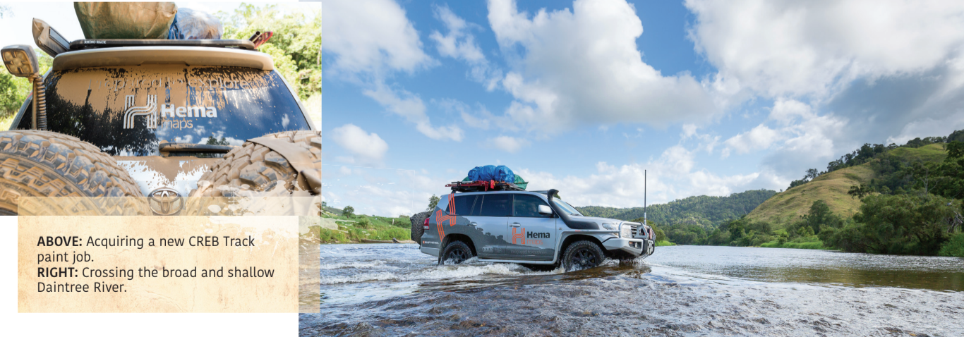
Hidden by deep rainforest, the CREB Track’s red-clay surface and very steep angles mean that the slightest rainfall, even days old, can render the track nearly impassable.

Just over 60km long, it is one of the best, and most challenging 4WD trips in north Queensland. A brief drizzle mid- trip, not unlikely in this coastal rainforest, and going downhill becomes an exercise in careful braking and steering. Even mud tyres have a hard time with this stuff. In the old days, when this was the only road up the coast, everyone would fit chains to their tyres to cross this range. Now, the Douglas Shire Council closes the track for much of the year, warning that if you travel on a ‘closed road’, you’ll have to pay for your own rescue.

The Council does not recommend towing, but the careful driver, on a very dry day, can make it through unscathed, although not unnerved. It’s worth planning your trip carefully, because what looks like a two- or three–hour trip can actually become a

much longer drive if conditions are not optimal.

With World Heritage–listing, this area is particularly sensitive, and travellers should respect the land and stay on the Track. From Cooktown the Mulligan Hwy heads south until you get to the Helenvale turn, which takes you past the legendary Lions Den Hotel. About

33km later you arrive in Ayton. From here you can travel down the CREB Track, or the Bloomfi eld Track if the CREB is closed.

The first 15km or so of the CREB are relatively easy – a winding gravel road through the rainforest, with great views and waterfalls along the way. As you get into the heart of the McDowall Range, though, the Track shows its true colours. This continues until you drop out of the Range to the Daintree River, a broad shallow crossing, and find yourself in the sleepy town of Daintree.


HISTORY

Carved through the Daintree Rainforest by the Cairns Regional Electricity Board (CREB), the Track became obsolete when the Bloomfi eld Track was cut closer to the coast. It now operates solely as a recreational track and southern access to the Burungu land at China Camp.

For thousands of years, the Kuku Yalanji people have lived in this region. The path of the CREB Track mostly follows ancient Aboriginal foot trails. After Captain Cook and his crew took refuge in Cooktown in 1770, few white men visited for almost 100 years. Kennedy’s expedition in 1848 bypassed this section of coast, highlighting how difficult the terrain was, and still is. The 1873 discovery of gold in the Palmer River essentially built Cooktown and plenty more ghost settlements like Maytown, but the area around the CREB Track was primarily mined for tin.


BLOOMFIELD TRACK

While not as technically challenging as the CREB Track, the Bloomfi eld Track cuts through the same coastal rainforest, crossing numerous creeks and scaling some impossibly steep hills. Running from Cape Tribulation in the south to Wujal Wujal in the north, it is 4WD-only. However, it is much more forgiving than the CREB, with concrete on the steepest sections and graded gravel the rest of the way. The track is subject to seasonal fl ooding, slips, loss of traction, potholes and fallen trees.

Built in 1984 amid much controversy, this is the most direct route between Cairns and Cooktown. Incidentally, the uproar caused by the road’s construction led, eventually, to World Heritage–listing and a ban on logging four years later.

Facilities are available as far north as Cape Tribulation, and there is no camping along the Track. For information contact the Douglas

Shire Council Ph (07) 4099 9444,

www.douglas.qld.gov.au/road-

conditions/bloomfield-track.


4WD ADVENTURES TOP 100 - TRACK #2 - THE BLUFF - BINDAREE CIRCUIT

GRADING: 4WD, Medium.

TIME: One Day.

DISTANCE: 143KM, Merrijig return. 

LONGEST DISTANCE WITHOUT FUEL: 158KM, Mansfield to Mirimbah.

BEST TIME OF YEAR: Spring and Summer.

PERMITS AND FEES:   None apply. 

MAPS: Hema's 'The High Country Victoria'


THE DRIVE

This delightful and often challenging drive around The Bluff starts and ends at the pub at Merrijig, 13km east of Mansfield.

Just 2km from the pub, turn onto the Howqua Tk and climb to the Timbertop Saddle before descending to the Howqua Hills Historic Area, where there are a few private shacks scattered along the Howqua River. You cross the stream and pass through the large and popular Sheepyard Flat camping area before veering left onto Brocks Rd.

You’ll pass a number of delightful camping areas scattered along the Howqua River before the road climbs seriously to Eight Mile Gap. Stay on Brocks Rd as it descends into the Jamieson River valley, passing the short but steep track to Upper Jamieson Hut. From here the road is never far from the river and there are a number of small pleasant campsites established by the Australian Trout Foundation.

The road then climbs away from the stream becoming a more serious and narrower 4WD track along the way as it switches through a number of sharp rocky turns to reach the snow gum shrouded crest of the Great Dividing Range.

The Australian Alps Walking Track, which links the tiny township of Walhalla to distant Canberra, via the high peaks of the continent, passes through here.

From this point, you can also continue east on the King Billy Tk to meet with the Howitt Rd for an easy drive south to Arbuckle Junction and on to Licola.

Our route lays along with the very rocky and rough Bluff Tk, which is slow going all the way past King Billy No. 1 to Lovicks Hut. The route passes through some fine stands of snow gums untouched by recent fires and past an ancient (some say at least 500 years old) large, low, gnarled snow gum that has been declared one of the 50 most significant trees in Victoria. There are some great views along this section of track over the surrounding ranges, which are even better from Picture Point that gives expansive views north to Mt Buller, Mt Stirling, Mt Howitt and the Devils Staircase. However, most good views along here are only available if you park your vehicle and take a short walk. As well, bush campsites (no facilities) can be found, mainly in the grassy saddles amongst the gums.

From Lovicks Hut the track improves as it reaches Bluff Hut then starts to descend where you need to turn right, then left, onto 16 Mile Jeep Tk. This drops steeply in parts to come out again at the beautiful Howqua River at Pikes Flat. The track then climbs a short way from the river and then drops to Bindaree Hut and its large river flat, ideal for camping.

Bindaree Rd is joined a short distance later and this good dirt road climbs the range to Circuit Rd. Along the way, you’ll pass the parking area for Bindaree Falls which is a 10-minute walk from the road. You can wander right under the waterfall; a magnificent experience on a hot day.

Once on Circuit Rd turn left towards Howqua Gap. From Howqua Gap Hut it’s 7km to Telephone Box Junction (TBJ) with its Mt Stirling Resort buildings.

From here Mt Stirling Rd descends to Mirimbah where the bitumen begins at Mt Buller Rd. Turn right, passing Carter Rd near Sawmill Settlement, before returning to Merrijig.


MOUNTAIN CATTLEMEN’S HERITAGE

The Stoney and Lovick families have left a lasting impression on the High Country. Eadley Stoney built Bluff Hut with the help of his son, Graeme, in the 1950s, carrying their materials by packhorse.

Eadley Stoney was considered a character and community leader – hardened and moulded by life in the High Country. The mountain behind Bluff Hut was dubbed Mt Eadley Stoney after he died in 1972.

In 1992, Graeme Stoney was elected to the Upper House of State Parliament and spent much of his time advocating for the rights and issues that affected mountain people, something he continues to do today.

The Lovick family was one of the earliest to settle in this region. Charlie Lovick grew up to be a well-known horseman who was Master of Horse for both The Man From Snowy River movies and whose horse, Denni, was ridden in both films.

The Stoney and Lovick families have both been involved in a mixture of farming and grazing, and leading cross-country skiing, hiking and horseriding tours, and sharing their beloved country with anyone who was interested. More recently they have rebuilt the huts destroyed by bushfires and are all involved in their communities including the annual Mountain Cattlemen’s Association of Victoria (MCAV) Get Together – a weekend of horsemanship, bush skills, stories and mateship that everyone who loves the mountains should experience at least once.


4WD ADVENTURES TOP 100 - TRACK #55 - STEEP POINT & DIRK HARTOG ISLAND 

GRADING: 4WD Medium

TIME: One Day

DISTANCE: 248KM, Overlander Roadhouse to Cape Inspection Lighthouse 

LONGEST DISTANCE WITHOUT FUEL: 568km, Overlander Roadhouse Return

BEST TIME OF YEAR: May and June

PERMITS AND FEES:  National park entry fees apply or Edel Land National Park. National park camping fees apply for Edel Island and Dirk Hartog Island national parks. Access to Dirk Hartog Island is by a privately operated barge from Steep Point which operates from March to October.

MAPS: Hema's Mid West Western Australia.


THE DRIVE 

Leaving the North West Coastal Hwy at the Overlander Roadhouse, head west on Shark Bay Rd past Hamelin Pool for 41km to turn off onto Useless Loop Rd. The track soon hugs the southern reaches of Henri Freycinet Harbour – it’s best to drop your tyre pressures at the first dirt as this track is famous for its corrugations! 

As the track leaves the salt plain and crosses into Edel Land National Park, it drops from a dual-track to a single. While the corrugations continue, they are now joined by sections of soft sand and some steeper climbs, twists and turns that may test those either heavily laden or towing.

Further along and you will be driving parallel to some stunning pristine dunes before a final run along the shoreline approaching the Ranger Station and finally the campsites at Shelter Bay. 

Those choosing to spend time over at Dirk Hartog Island will catch the barge across to the Island from Shelter Bay. The barge takes one 4WD or one 4WD plus one camper trailer across at a time. It’s an adventurous experience that commences with a reverse beach landing near Cape Ransonnet . 

The Island is a national park with restricted visitor numbers. There is a choice of camping with facilities at the Homestead, or at a handful of facility free locations spread across the Island. Be warned that going can be slow when traversing the Island’s network of sometimes soft, corrugated or rocky single-lane tracks. 

THINGS TO DO 

A photograph at Steep Point (the westernmost point of the Australian mainland) is a must. Fishing from the cliffs or by boat is popular, and it’s also a great place for water sports. 

Dirk Hartog Island is Western Australia’s largest island and there is a lot to see. The west coast is rugged with steep cliffs and blowholes, and in season, spectacular views of migrating humpback whales. The east coast is generally more protected, and its bays are filled with great beaches and marine wildlife. Cape Inscription Lighthouse, at the northern point, is a place steeped in history. In 1616 Dirk Hartog ‘discovered’ the Island. His was the second recorded European landing on the Australian continent, and the first on the west coast. 

If you have time, there’s plenty to explore back near the highway, including the ancient stromatolites at Hamelin Pool. In fact, the entire World Heritage–listed Shark Bay area is worth exploring.

WARNINGS

Drop tyre pressures to 18-20psi or lower at the windmill.

The closest fuel is at Overlander Roadhouse so you will need extra fuel to explore the length of the Island freely.

Off-road camper trailers and boat trailers can be taken but it can be hard going so they need to be heavy duty.

Use extreme caution near cliff edges, especially when fishing.

Campfires are not permitted.

4WD ADVENTURES TOP 100 - TRACK #38 - SAVANNAH WAY - NORMANTON TO MATARANKA

GRADING: AWD (with caution)

TIME: Three days minimum.

DISTANCE: 1,346KM, Normanton to Mataranka 

LONGEST DISTANCE WITHOUT FUEL: 524KM, Cape Crawford to Mataranka; 316KM Hells Gate Roadhouse to Borroloola

BEST TIME OF YEAR: June to October.

PERMITS AND FEES:   Camping fees apply for both Elsey and Limmen national parks.

MAPS: Hema's 'Top End & Gulf'


THE DRIVE 

The entire Savannah Way stretches for approximately 3,700km from Cairns in Queensland across the Northern Territory to Broome in Western Australia. This drive has been designed to allow visitors to explore just a section or the entire route and our trip focuses on the leg between Normanton and Mataranka . Heading west from Normanton, the country varies from scrubby and gently undulating to grassy and flat, with little to excite the casual observer. However, if you’re at all interested in history you’ll want to stop at the site of Burke & Wills’ Camp 119 and the Leichhardt River crossing. Leaving Burketown you kiss the grasslands goodbye and say hello to the scrubby savannah woodland that keeps you company to beyond Wollogorang. About 34km from Burketown, the Gregory River crossing is one of the track’s gems. Most of the major crossing points en route are disappointingly desolate places, but the Gregory is just what you’d expect of a large tropical river – clear water running between banks lined by luxuriant vegetation, inhabited by abundant birdlife and lurking crocodiles. Call into the Tirranna Springs Roadhouse, 1km before the crossing, for some local fishing tips (if you have time, make sure to detour to Boodjamulla National Park – see Track 37). Continue on another 60km or so before the road crosses the broad rocky bed of the Nicholson River, with the large Aboriginal community of Doomadgee on its far bank. Despite its name, the Hells Gate Roadhouse is a friendly little place – travellers need to remember there are no facilities between here and Borroloola (316km — see map on next page). The actual Hells Gate is a pass-through some low, lumpy hills about 1km back down the road. From here it is 54km to the NT border, where you set your watch back 30 minutes.

Beyond Wollogorang Station are some sizeable hills – a rarity in this area. About 17km past the homestead you enter a steep-sided valley before a short climb puts you on top of the range near the now-defunct Redbank Mine. For another 10km or so the track winds about through stony hills with a sparse cover of white-barked gums, after which it becomes a series of long straights cutting across narrow river valleys. The vegetation improves beyond the hills, taking on more of a tropical appearance – tall cycads are an unusual feature near the Foelsche and Wearyan crossings. Watch out for large concealed rocks in the Wearyan. Beyond Borroloola, stop to see the towering sandstone formations in Caranbirini Conservation Reserve on the way to Cape Crawford. The road from Cape Crawford up to the Roper Hwy is dirt all the way and crosses hundreds of kilometres of oftenrough floodplain country through Limmen National Park. (See Track 39 for more details.) This section is the track’s most interesting and varied in terms of scenery and driving conditions and features impressive ‘Lost City’ formations that in themselves make the long drive worthwhile. For the last stretch to Mataranka just follow the sealed Roper Hwy. 

THINGS TO DO 

Normanton, the major business and service centre in the Gulf, has many historical buildings. One of the town’s most attractive old buildings, the Normanton Railway Station is also home to the Gulflander railmotor. Every Wednesday the Gulflander leaves Normanton for Croydon: it returns on Thursdays. During the dry season, fishing enthusiasts flock to Karumba – the centre of the Gulf’s lucrative prawning industry. A major access point to the Gulf, Karumba is also known for the unusual Morning Glory cloud formation: seen from mid-August to November. Keen historians will want to visit the site of Burke & Wills’ Camp 119: this gloomy spot among stunted coolabahs was the ill-fated explorers’ most northerly campsite. At the broad Leichhardt River Crossing there’s a seasonal waterfall just down from the causeway, and thoughts of a swim in the plunge pool are tempting – until you see the crocodile warning signs! Leichhardt himself crossed the river hereabouts on 10 August 1845. Burketown has a couple of interesting historical sites including the old Burketown Pub and the remains of an 1860s boiling-down works. Fishing is a popular activity and you can try your luck off the town wharf, or take a charter. Borroloola is well serviced, with fishing charters, and hire boats available. Fishermen come for the much-prized barramundi, reef fish and mud crabs on the McArthur River or at King Ash Bay. Also of interest is the museum, which houses displays that tell fascinating tales of yesteryear. The headquarters of the King Ash Bay Fishing Club is on the McArthur River 43km by road downstream from Borroloola. During the dry season, the river bank here is sheer chaos as thousands of anglers come from far and wide to try their luck. The small Caranbirini Conservation Reserve includes a number of dramatic ‘Lost City’ formations as well as a seasonal waterhole. You can explore this area on the 2km Barrawulla Loop Walk or take the 5km Jagududgu Look Walk, which leads you to a lookout with fine views of the massif. What is reputed to be one of northern Australia’s most spectacular ‘lost cities’ forms part of the Abner Range, near the Heartbreak Hotel at Cape Crawford. The formations are on private property and are only accessible by helicopter. Limmen National Park includes a number of estuary and river fishing locations as well as sandstone formations. The little township of Mataranka is mainly known as the jumping-off point for visits to the Thermal Pool in nearby Elsey National Park. Developed during WWII as a recreation area for the defence forces, the pool is naturally heated to a pleasant 34°C – just right for soothing away the aches and pains brought on by the long drive. As well as the famous springs, the Park includes the upper reaches of the Roper River that are ideal for swimming, canoeing and fishing. Another popular stop is the Elsey Cemetery, south of Mataranka, to learn about old Elsey Station which was immortalised in Jeannie Gunn’s novel, We of the Never Never. 

THE GULF TRACK 

Now part of the Savannah Way, the Gulf Track roughly follows in the footsteps of Ludwig Leichhardt, who passed this way on his epic journey from Brisbane to Port Essington in 1844 and '45. The original Gulf Track ran from Lake Woods near Burketown to Abrahams Billabong near Mataranka. Pioneered by the drover George de Latour in 1873 it became the route by which cattle from Queensland were walked to the Top End and Kimberley in the 1870s and ’80s. Drovers attempting it were faced with a daunting task – the terrain was harsh and the feed was poor. In the early days at least, once they left Burketown the drovers were going solo until they reached Roper Bar. In 1885 a store was built at Burketown Crossing (present-day Borroloola), just in time to greet would-be diggers heading for the newly discovered goldfield at Halls Creek, in the Kimberley. Many were on foot and illprepared for the rigours of the journey, so it’s probably fair to say that by 1890, when the great cattle drives and gold rush were over, the track had become lined by many unmarked graves. 

THE DRIVE 

This spectacular track starts in Dargo as you head north up Dargo High Plains Rd passing Farm Junction and Grant Junction, the road turns to gravel 21km from Dargo as it passes through the Freda Treasure Tree Reserve. Nearly 26km from Dargo a track on the left leads 100m to Treasure’s - Mt Ewen Huts, which is in fact a collection of old huts in varying stages of disrepair. There are a couple of spots to bush camp around here, if not at the huts themselves.

The Gows Hotel site can be found just to the east of the road 43km north of Dargo. Just 200m south from here, opposite Ritchie Rd, there is a small grave to a pioneer woman who died here. 

You’ll pass through an area of fenced high plains grazing land, and come to Lankey Plain where you turn east onto the King Spur Tk to Mayford. 

Just off Dargo Rd a track on the left leads 300m to Lankey Plain Hut. Back on the King Spur Tk you pass through a gate and close to the junction of the Long Spur Tk – to the south there are some fabulous views and spectacular bush campsites overlooking Devils Hollow . 

From here the track deteriorates and descends steeply into the Mayford Valley. Once at the bottom of the range, 11km from the Dargo Rd, you’ll enter a cleared area and pass some bush campsites and cross the upper reaches of the Dargo River. There are three more crossings of the stream in the next 3km before you reach the track’s end at the far side of the clearing that was once the old townsite of Mayford. Very little remains to be seen here, although an occasional pile of rocks is testimony to an old hut or building. 

Back on the main Dargo Rd it is just 6km to the junction of Blue Rag Range Tk, just 59km direct from Dargo and 12km south of the Great Alpine Rd. 

Turn onto the Blue Rag Range Tk, which immediately becomes steep. Just over 3km along you veer right, staying on the Blue Rag Range Tk with impressive  views of the track in front of you. A roller-coaster ride of just 7km from the Dargo Rd, that’s rutted and eroded in places, brings you to the Blue Rag Trig Point, and the most impressive views in all of the High Country. 

From here you’ll need to return to the Dargo Rd, as the Blue Rag Range Tk dead-ends at the Wongungarra River. Camping is possible at the end of the track, but there are no facilities and very little space. Once back at the Dargo High Plains Rd, turn north for an easy run of 12km to the Great Alpine Rd at Mt Saint Bernard, just 12km from the resort of Hotham Heights. 

THINGS TO DO 

While you’re in the area, you should seriously consider taking time out to hike the Razorback Walk. It is an amazing bushwalk from just north of Mt Saint Bernard to the summit of Mt Feathertop – the state’s second highest mountain. You can make the adventure a day-long outing or spend the night at Federation Hut. If you walk this trail in springtime or early summer, you’ll enjoy the High Country’s diverse array of alpine wildflowers. Hunting for deer is allowed in much of the area south of Hotham and across the Dargo High Plains. Fishing for trout and native species is reasonable in the headwaters of both the Wongungarra and Dargo rivers. The McMillan’s Walking Track crosses Dargo Rd near Lankey Plain. For experienced, well equipped walkers it can be followed south to Talbotville (50km, 3 days) or east to the Victoria River via Mayford (25km, 2 days).


4WD Adventures Top 100 - Track #3

GRADING:

4WD, Medium TIME One day. 

DISTANCE 

107km, Dargo to Mt St Bernard via Mayford and Blue Rag Trig Point. 

LONGEST DISTANCE WITHOUT FUEL 

158km, Dargo to Bright. 

BEST TIME OF YEAR 

Late spring to early autumn. Seasonal road closures apply during winter.

4WD Medium

Rawnsley Park Station’s self-drive Arkapena track ticks all the boxes required to justify the fee. Central to the experience are the stunning sedimentary geology of the Chace Range and some steep, rugged driving that keep you on your toes. After picking up the key at Rawnsley Park, the track begins along Flinders Ranges Road and heads east towards the Chace Range vehicles’ a comma and: as it parallels the range and crosses a number of creeks before swinging away from the rugged peaks.

The first 22km of the drive are nice and easy, and can even be driven by 2WD vehicles,: as it parallels the range and crosses a number of creeks before swinging away from the rugged peaks. This section lets drivers soak in the sights, while discovering some of the region’s history at a few suggested stops along the way.

Upon reaching Martin’s Well Road the driving becomes more engaging. From the road the route winds through dense stands of native pine, climbing steeply in parts across the ridge of range country. The steep climb to Prelinna Lookout will require low-range 4WD and rewards drivers with stunning views in every direction, including Wilpena Pound, the Heysen, Chace, ABC, Druid and Elder Ranges.

Sign your name in the visitor’s book before making your descent, then amble back toward Rawnsley Park.


Track 3 - Arkapena Track

Medium grade, 4-5 Hours driving time, total ditance of 34km.

Permits required $50 for 4WD's plus a $10 key deposit, payable at Rawnsley Park Station.

Rawnsley Park Station

Ph (08) 8648 0700, UHF channel 13

Highlights

Chace Range and Prelinna Lookout