Gallery


About
The Track
4WD ADVENTURES TOP 100 - TRACK #2 - THE BLUFF - BINDAREE CIRCUIT
GRADING: 4WD, Medium.
TIME: One Day.
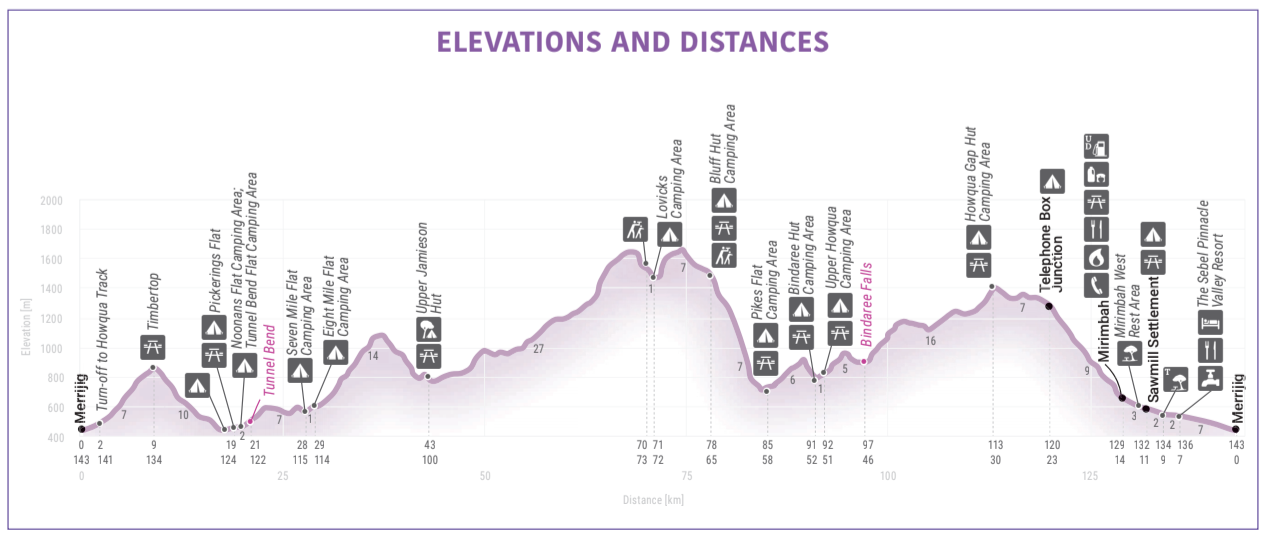
DISTANCE: 143KM, Merrijig return.
LONGEST DISTANCE WITHOUT FUEL: 158KM, Mansfield to Mirimbah.
BEST TIME OF YEAR: Spring and Summer.
PERMITS AND FEES: None apply.
MAPS: Hema'S 'The High Country Victoria'
THE DRIVE
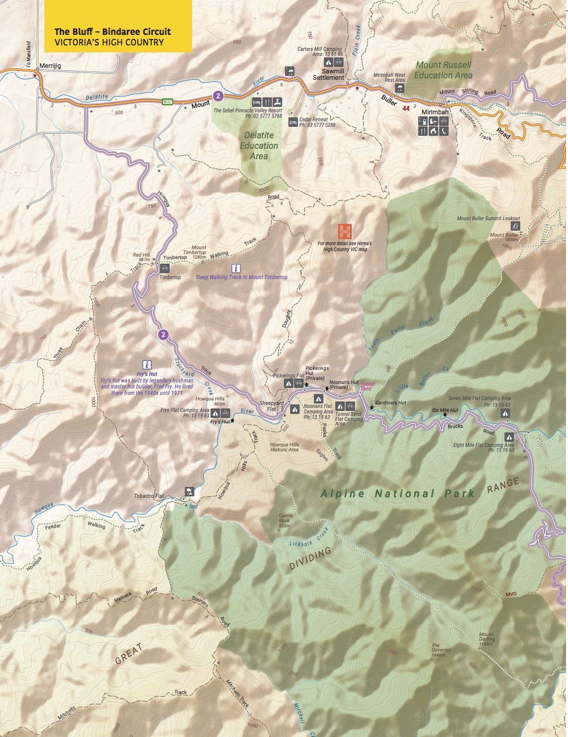
This delightful and often challenging drive around The Bluff starts and ends at the pub at Merrijig, 13km east of Mansfield.
Just 2km from the pub, turn onto the Howqua Tk and climb to the Timbertop Saddle before descending to the Howqua Hills Historic Area, where there are a few private shacks scattered along the Howqua River. You cross the stream and pass through the large and popular Sheepyard Flat camping area before veering left onto Brocks Rd.
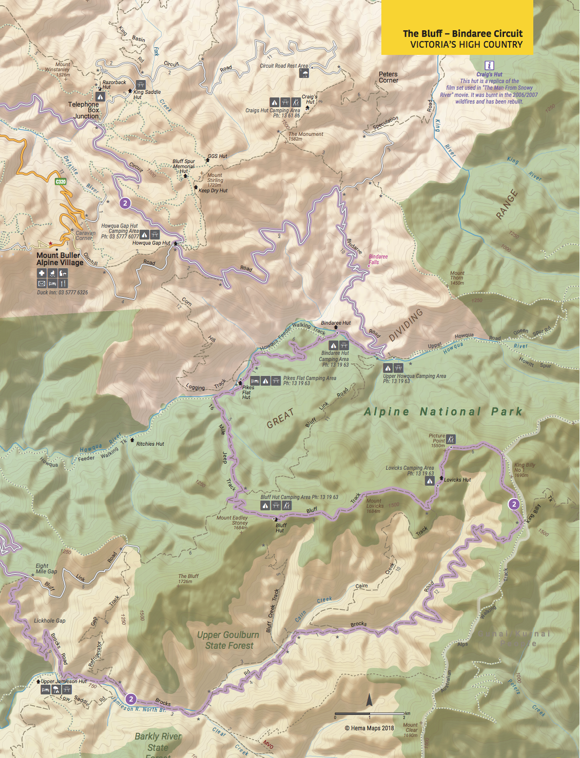
You’ll pass a number of delightful camping areas scattered along the Howqua River before the road climbs seriously to Eight Mile Gap. Stay on Brocks Rd as it descends into the Jamieson River valley, passing the short but steep track to Upper Jamieson Hut. From here the road is never far from the river and there are a number of small pleasant campsites established by the Australian Trout Foundation.
The road then climbs away from the stream becoming a more serious and narrower 4WD track along the way as it switches through a number of sharp rocky turns to reach the snow gum shrouded crest of the Great Dividing Range.
The Australian Alps Walking Track, which links the tiny township of Walhalla to distant Canberra, via the high peaks of the continent, passes through here.
From this point you can also continue east on the King Billy Tk to meet with the Howitt Rd for an easy drive south to Arbuckle Junction and on to Licola.
Our route lays along the very rocky and rough Bluff Tk, which is slow going all the way past King Billy No. 1 to Lovicks Hut. The route passes through some fine stands of snow gums untouched by recent fires and past an ancient (some say at least 500 years old) large, low, gnarled snow gum that has been declared one of the 50 most significant trees in Victoria. There are some great views along this section of track over the surrounding ranges, which are even better from Picture Point that gives expansive views north to Mt Buller, Mt Stirling, Mt Howitt and the Devils Staircase. However, most good views along here are only available if you park your vehicle and take a short walk. As well, bush campsites (no facilities) can be found, mainly in the grassy saddles amongst the gums.
From Lovicks Hut the track improves as it reaches Bluff Hut then starts to descend where you need to turn right, then left, onto 16 Mile Jeep Tk. This drops steeply in parts to come out again at the beautiful Howqua River at Pikes Flat. The track then climbs a short way from the river and then drops to Bindaree Hut and its large river flat, ideal for camping.
Bindaree Rd is joined a short distance later and this good dirt road climbs the range to Circuit Rd. Along the way, you’ll pass the parking area for Bindaree Falls which is a 10-minute walk from the road. You can wander right under the waterfall; a magnificent experience on a hot day.
Once on Circuit Rd turn left towards Howqua Gap. From Howqua Gap Hut it’s 7km to Telephone Box Junction (TBJ) with its Mt Stirling Resort buildings.
From here Mt Stirling Rd descends to Mirimbah where the bitumen begins at Mt Buller Rd. Turn right, passing Carter Rd near Sawmill Settlement, before returning to Merrijig.
MOUNTAIN CATTLEMEN’S HERITAGE
The Stoney and Lovick families have left a lasting impression on the High Country. Eadley Stoney built Bluff Hut with the help of his son, Graeme, in the 1950s, carrying their materials by packhorse.
Eadley Stoney was considered a character and community leader – hardened and moulded by life in the High Country. The mountain behind Bluff Hut was dubbed Mt Eadley Stoney after he died in 1972.
In 1992, Graeme Stoney was elected to the Upper House of State Parliament and spent much of his time advocating for the rights and issues that affected mountain people, something he continues to do today.
The Lovick family was one of the earliest to settle in this region. Charlie Lovick grew up to be a well-known horseman who was Master of Horse for both The Man From Snowy River movies and whose horse, Denni, was ridden in both films.
The Stoney and Lovick families have both been involved in a mixture of farming and grazing, and leading cross-country skiing, hiking and horseriding tours, and sharing their beloved country with anyone who was interested. More recently they have rebuilt the huts destroyed by bushfires and are all involved in their communities including the annual Mountain Cattlemen’s Association of Victoria (MCAV) Get Together – a weekend of horsemanship, bush skills, stories and mateship that everyone who loves the mountains should experience at least once.